Damages in Natori city caused by the Great East Japan Earthquake
本資料は,名取市教育委員会学務専門員の八森伸先生が作成された資料(日本語版)を基にしています。
ALTのセーラ・J・ブラウン先生(名取市立増田中学校所属)に協力していただき,英語版として作成いたしました。
1 About Natori city
Natori city is located in the flat plains south of Sendai city in Miyagi prefecture and faces the Pacific Ocean.
In 2011, about 73,000 people lived there.
Along the sandy coast, there were two main residential areas, Yuriage with 7,100 residents and Shimomasuda with 4,700 residents.
2 Damages caused by the Great East Japan earthquake in Natori city
The Great East Japan earthquake (Mw=9.0) occurred at 14:46 on Friday, March 11, 2011.
After the occurrence of the earthquake, a tsunami reached the Yuriage coast at around 15:55 and its height at Yuriage port was 8.8m.
Yuriage and Shimomasuda were badly damaged by this massive tsunami.
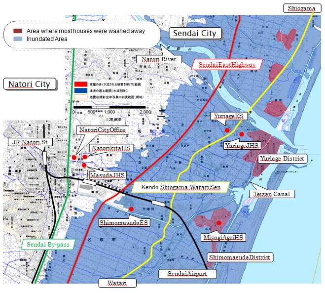
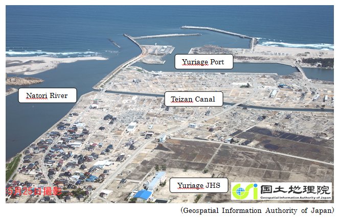
All buildings, houses, shops and greenhouses east of Teizan canal were washed away and most houses in the area between Teizan canal and Kendo Shiogama-Watari Sen, the prefectural road which connects Shiogama and Watari, were damaged very seriously.
And the area from the coast to the Sendai East Highway was covered with a huge heap of rubble.
The tsunami, which went through the girder bridge of the Sendai East Highway, reached near the Sendai By-pass and thousands of rice paddies were inundated with sea water.
In Natori city, 964 people were killed by the tsunami and 41 people died under the influence of the Great East Japan earthquake. (These are the figures for January 31, 2014)
3 Damages on schools
The ground floor of Yuriage Junior High School and Yuriage Elementary School were washed away and many cars and fishing boats were swept into the school yards.
Miyagi Agricultural High School, located nearest to the ocean, was struck by a two-storey-high wave and almost all facilities were destroyed.
All of Natori's municipal schools were appointed as official shelters, so just after the massive earthquake, hundreds of people voluntarily gathered at Yuriage Junior High School, Yuriage Elementary School, Shimomasuda Elementary School and some other schools.
Student casualties: 23 (Yuriage Elementary School 1, Yuriage Junior High School 14, Shimomasuda Elementary School 5, Masuda Junior High School 3)
Teacher casualty: 1 (Natori Daiichi Junior High School)
4 Current state of schools
(1) Yuriage Elementary School
2011.03.29 Closing Ceremony at Nachigaoka Elementary School
2011.04.21 Restarted at Fujigaoka Elementary School where Yuriage Elementary School borrows its facilities.
Out of 229 students, some 70 transferred to other schools because of the earthquake.
2014.04.01 124 students attending Yuriage Elementary School and 8 buses in service for students who live in remote areas in and out of Natori city
(2) Yuriage Junior High School
2011.03.29 Closing Ceremony at Nachigaoka Elementary School
2011.04.21 Opening Ceremony at Fujigaoka Elementary School
Out of 127 students, some 20 transferred to other schools because of the earthquake.
2012.08.26 School restarted at the newly built temporary school building in Jyusanzuka Park.
2014.04.01 103 students learning at the temporary school building and 7 buses in service for students who live in remote areas in and out of Natori city
5 Action for reconstruction
Natori city and Natori city Board of Education decided to reconstruct Yuriage Elementary School and Yuriage Junior High School in Yuriage.
During 2012, 'Yuriage Elementary School and Yuriage Junior High School Saiken Konwakai', the gathering for friendly discussion about the reconstruction of Yuriage Elementary School and Yuriage Junior High School, was held seven times.
The proposal for the reconstruction of these two schools was presented on October 11 in 2012.
Natori city Board of Education decided the basic policy for the reconstruction project on January 28, 2013.
Now, 'Yuriage Elementary School and Yuriage Junior High School Saiken Kyougikai', the conferences for the reconstruction of Yuriage Elementary School and Yuriage Junior High School, are being held to make concrete plans.
Natori city Board of Education aims to complete the project by spring in 2017.
Figure 1: Tsunami inundation map of Natori city

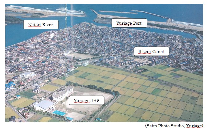
Figure 2: Aerial view of Yuriage district before the disaster (2008)

Figure 3: Aerial view of Yuriage district after the disaster (May 25, 2011)

Figure 4: Pictures of inundated Yuriage (from the rooftop of Yuriage JHS, March 11-12, 2011)


Yuriage Junior High School served as a temporary evacuation center.
Many cars, fishing boats and even houses were swept into the school yard.
Figure 5: Pictures of Yuriage JHS (about a week after the tsunami)

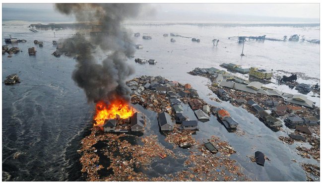
Figure 6: Houses engulfed in flames in Yuriage district (16:08 March 11, 2011, Kahoku-Shimpo)

Figure 7:

Left - Major historical tsunamis and the expected Miyagi-Oki earthquake and location of the main shock
Right - Tsunami height distribution of the 2011 Great East Japan tsunami and of the historical 1611 Keicho-Sanriku, 1896 Meiji-Sanriku and 1933
Showa-Sanriku tsunamis
(H. Murakami, K. Takimoto & A. Pomonis, 2012)
Figure 8: The stone monument built in 1933 in Yuriage

78 years before the Great East Japan Earthquake, there was the Showa-Sanriku tsunami on March 3, 1933. Its height in Yuriage was about 2m. People built a stone monument in Yuriage district. It said 'When an earthquake occurs, keep an eye out for tsunami.'
In spite of this caution, people had forgotten the destructiveness of tsunamis and thought that tsunamis would not come across Teizan Canal.
But that confidence was misplaced.
We should pass on our experiences of the Great East Japan Tsunami for our future generations.